Satellite “RISING-2” Progressing Well in Preparation for Full-Scale Observation
Research Press Release | June 24, 2014
-
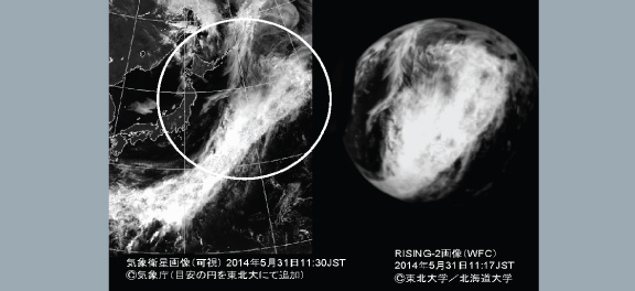 Ref. 1 Observation Date and Time: May 31, 2014, 11:17 (Japan time) (Image of Earth During the Day) For comparison, the image is shown side-by-side with a visible image taken by the weather satellite “MTSAT” (Himawari). The same cloud formation is observed in both images. A circle with a radius of 1,000 km is added as a guide to the meteorological image.
 -
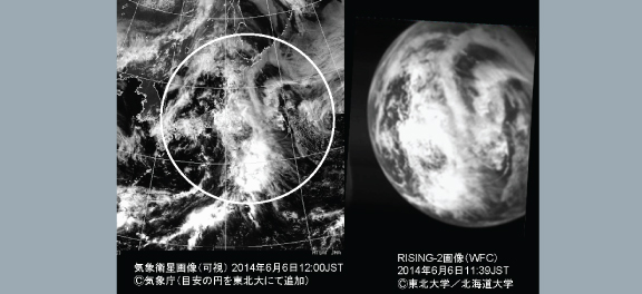 Ref. 2 Observation Date and Time: June 6, 2014, 11:39 (Japan time) (Image of Earth During the Day) For comparison, the image is shown side-by-side with a visible image taken by the weather satellite “MTSAT” (Himawari). The same cloud formation is observed in both images. A circle with a radius of 1,000 km is added as a guide to the meteorological image.
 -
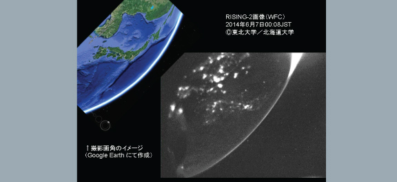 Ref.3 Observation Date and Time: June 7, 2014, 0:08 (Japan time) (Image of Earth at Night) The image shows an eastern view over the East China Sea. The Japanese Archipelago is seen in the center of the image, and the bright area in the upper right corner indicates the earth's atmosphere where sunlight is starting to shine. For comparison, an image generated by GoogleEarth with the same angle of the view is attached.
| Press Release | ||
|---|---|---|
| Key Points | – The earth observation micro-satellite “RISING-2” was successfully launched from Tanegashima Island on Saturday, May 24.
– Imaging tests using a fish-eye CCD camera (WFC) were successfully carried out. – Attitude control of the satellite using reaction wheels were verified by the test. |
|
| Overview |
The earth observation micro-satellite “RISING-2”, jointly developed by Tohoku University and Hokkaido University, was launched from the Tanegashima Space Center in Kagoshima Prefecture on Saturday, May 24. The satellite is functioning properly after its launch. Imaging tests using the fish-eye CCD camera (WFC) and satellite attitude controls using reaction wheels were carried out, and normal functioning of the instruments was confirmed. Some images taken up to the night of June 6, two weeks after launch, are shown here. Imaging tests using a High-Precision Multi-Spectral Telescope System (HPT) and Bolometer Array (BOL) are scheduled in preparation of a full-scale scientific observation. (Background) Development of the “Rising-2” satellite began in 2009. Hokkaido University was placed in charge of scientific payload and Tohoku University of the satellite bus system. The satellite weighs approx. 43 kg, and was successfully launched aboard the H-IIA-24 rocket as piggyback payload on JAXA’s ALOS-2 satellite (DAICHI-2). The advanced observation instruments were installed on RISING-2 including a multi-spectral High-Precision Telescope (HPT), the world’s first telescope system capable of photographing with 5-meter GSD in the 400 wavelength range, and transient luminous events (sprites) observation instrument. For the operation of these instruments, RISING-2 is aimed at achieving the world’s highest level of accurate attitude control of a micro-satellite. (Study Results) RISING-2 continues to fly smoothly after launch. Up to the present, imaging tests carried out using the highly sensitive CCD camera (WFC) on the clouds on the day side near Japan as well as night views were successfully observed. In addition, satellite attitude control using reaction wheels was carried out, and normal functioning of the instrument was confirmed. (Future Prospects) We will continue to conduct various tests in order to confirm normal functioning of all the instruments, and we are planning to begin full-scale observations within a month. As a micro- satellite of this size, earth observation with a 5-meter GSD is the world’s highest class. It is also equipped with the world’s first space Liquid Crystal Tunable Filter that allows wavelength-selection, and multispectral imaging with the highest resolution in the world among all artificial satellites—including larger ones—can be achieved. This technology will pave the way for forest measurements that will serve as basic data for CO2 Emissions Trading, AI agriculture,*1 and space fishing.*2 *1: Agricultural information science uses high-precision measurement and information science technology, and takes advantage of the experience and know-how of skilled farmers. *2: In next-generation fishing, fishing fields can be predicted and estimated based on satellite information. |
|
| Reference Material |
Explanation of Three Earth Images observed with a Fish-Eye CCD Camera (WFC) Mounted on “RISING-2” (Pictures 1-3 above) Ref. 1 Observation Date and Time: May 31, 2014, 11:17 (Japan time) (Image of Earth During the Day) For comparison, the image is shown side-by-side with a visible image taken by the weather satellite “MTSAT” (Himawari). The same cloud formation is observed in both images. A circle with a radius of 1,000 km is added as a guide to the meteorological image. Ref. 2 Observation Date and Time: June 6, 2014, 11:39 (Japan time) (Image of Earth During the Day) For comparison, the image is shown side-by-side with a visible image taken by the weather satellite “MTSAT” (Himawari). The same cloud formation is observed in both images. A circle with a radius of 1,000 km is added as a guide to the meteorological image. Ref. 3 Observation Date and Time: June 7, 2014, 0:08 (Japan time) (Image of Earth at Night) The image shows an eastern view over the East China Sea. The Japanese Archipelago is seen in the center of the image, and the bright area in the upper right corner indicates the earth’s atmosphere where sunlight is starting to shine. For comparison, an image generated by GoogleEarth with the same angle of the view is attached. |
|
| Inquiries |
Yukihiro Takahashi, Professor, Faculty of Science, HU Creative Research Institution Space Mission Center, Hokkaido University TEL & FAX: +81-11-706-9244 E-mail: smc@cris.hokudai.ac.jp |
|
|
Japanese Link |
「雷神 2」衛星が本格的な観測に向けて順調に調整中 | |