UNIFORM-1 Satellite Successfully Observes Mt. Ontake Eruption: Prompt Observation of the Disaster Via the Micro Satellite (50 kg)
Research Press Release | October 28, 2014
-
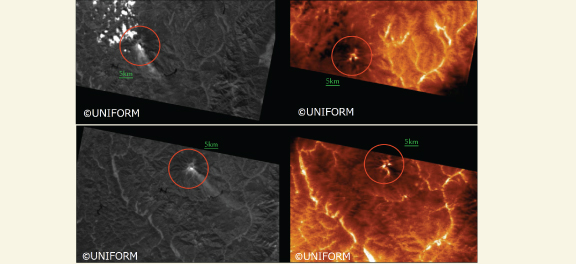 Images of Mt. Ontake taken by UNIFORM-1’s onboard thermal infrared camera: (Top) Images taken at 12:02 (JST), September 28 ;(Bottom) Images taken at 12:21 (JST), September 29; (Left) Visual camera (resolution: approx. 100 m); (Right) Thermal infrared camera (resolution: approx. 200 m) All images have been cropped from original ones and magnified. Upper direction is North. High temperature regions appear as white areas in thermal infrared images.
 -
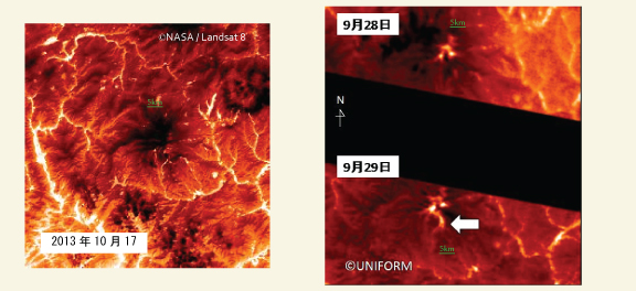 Images of Mt. Ontake taken by UNIFORM-1’s onboard thermal infrared camera: (Left)Thermal infrared image (TIRS band10) taken by LANDSAT8 on October 17, 2013; (Right)Thermal infrared images taken by UNIFORM-1 on September 28/29, 2014; From these images, hot spots caused by the eruption were observed. Compared with the September 28 image, a hotspot to the south is seen in the September 29 image. The camera identified the hotspot not only as a heat source on the surface of the ground, but also as heat source of the plume in the sky, etc. Furthermore the rise in ground surface temperature was shown to be caused not by the eruption but by the reflection of heat, etc. As a result of this data, a new eruptive crater is not indicated.
 -
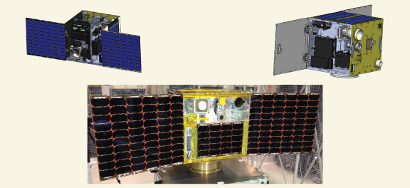 Overview images of UNIFORM-1: Mass/Size <50kg, <50 x 50 x 50 cm
| Press Release | ||
|---|---|---|
| Key Points |
・The UNIFORM-1 satellite, equipped with a thermal infrared camera developed by Hokkaido University successfully captured Mt. Ontake after it erupted. ・The camera has a resolution of approximately 200 m, and compared to other large satellites, its micro system has superior mobility and operation time occupancy. |
|
| Overview | At 11:53 am (Japan Standard Time (JST)), September 27, 2014, Mt. Ontake, located on the border between Nagano and Gifu Prefectures, erupted. The UNIFORM Project (Micro Satellite R&D Project, Ministry of Education, Culture, Sports, Science and Technology (MEXT)) represented by Wakayama University, with the cooperation of Hokkaido University and JAXA as collaborators, and the National Institute of Advanced Industrial Science and Technology, observed Mt. Ontake using visual and thermal infrared cameras onboard the first satellite of UNIFORM Project (UNIFORM-1). The information obtained immediately after the eruption on September 28 and afterward was provided to the Japan Meteorological Agency, Seismology and Volcanology Research Department. The thermal infrared camera has a resolution of approximately 200 m, and compared to other large satellites, its micro system has superior mobility and operation time occupancy. | |
| Inquiries |
Yukihiro Takahashi, Professor, Faculty of Science, HU Creative Research Institution Space Mission Center, Hokkaido University TEL & FAX: +81-11-706-9244 E-mail: smc@cris.hokudai.ac.jp |
|
|
Japanese Link |
UNIFORM-1 衛星で御嶽山噴火の観測に成功 ~超小型衛星(50kg)による災害即応観測~ | |
‹