RISING-2 Satellite Succeeds in High Resolution Spectral Imaging
Research Press Release | January 20, 2015
-
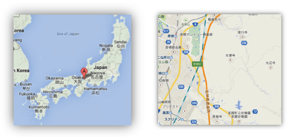 Fig. 1.1 NDVI map produced from RISING-2 images (2014/9/14) and Landsat-8(2013/8/14) images.
 -
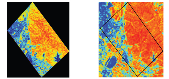 Fig.1.2
 -
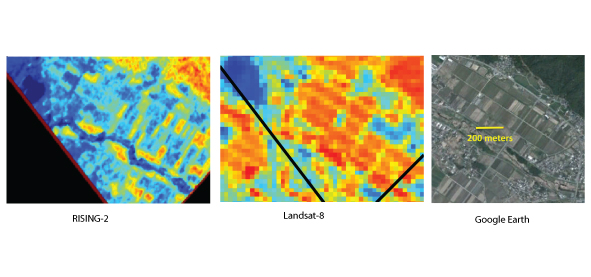 Fig. 2. Close-up of Fig. 1. Spatial resolution of NDVI map made from RISING-2 images is about 10 m, from which we can identify each typical unit of agricultural land. This resolution is the best in the world as a camera which has bands more than few hundreds. On the other hand, in the NDVI map from Landsat-8 we couldn’t see right distribution of NDVI.
| Press Release | ||
|---|---|---|
| Key Points | * The RISING-2 microsatellite has recently succeeded in high-resolution spectral imaging of the earth’s surface using a high-precision telescope (HPT) incorporating the world’s first liquid crystal tunable filter for space applications.
* A map was created of the earth’s surface at a resolution of approximately 10m based on an index (NVDI) indicating the distribution and activity of vegetation derived from images captured at multiple monochromatic wavelengths. Monochromatic imaging technology at this resolution, with the ability to select from a few hundred wavelengths, is a world-first in satellite observations, even for large satellites. * High-resolution spectral imaging opens the way to measure forests—data gathered forms the basic data for CO2 emissions trading— as well as monitor areas of disasters or pollution with high accuracy, and also allows for AI agriculture (Note 1) to achieve higher efficiency and higher quality, and also begets highly energy-efficient fishing (Note 2). Note 1: Agricultural Informatics employs sophisticated measurement and information science and technology and makes wide use of experienced and knowledgeable farmers with well-developed skills. Note 2: Advanced fishing operations which reduce fuel consumption by estimating and forecasting fishing area based on satellite data. |
|
| Overview | RISING-2, a micro-earth observation satellite developed jointly by Hokkaido University and Tohoku University was launched from the Tanegashima Space Center in Kagoshima prefecture on May 24th, 2014. A sequence of imaging experiments is underway.
Fisheye CCD cameras have previously been employed in typhoon and night photography, and RISING-2 achieved a world-first in 5m resolution color imaging on a 50kg class satellite using a high-precision telescope (HPT). The satellite proved successful in high-resolution spectral photography of the earth’s surface using the world’s first liquid crystal tunable filter for space applications incorporated in the high-precision telescope, and in creating a map of the earth’s surface at a resolution of approximately 10m based on a vegetation index (NVDI) derived from images observed at multiple monochromatic wavelengths. This paper shows a representative NVDI map thus obtained. Background Development had been ongoing since 2009, with Hokkaido University responsible for the scientific mission payloads, and Tohoku University responsible for the satellite bus system. The 43kg RISING-2 satellite was launched on an H-IIA rocket on May 24th, 2014. RISING-2 incorporates a small (length 38cm) and light (approximately 3kg), high-precision telescope. The telescope employs advanced technology in the form of a liquid crystal tunable filter developed together with the Sendai National College of Technology and a special ceramic mirror to achieve a world first in high-resolution imaging with 400 wavelengths. Research Results High-quality spectral imaging of Hikone city, Shiga prefecture at multiple wavelengths was carried out on September 14th, 2014. The images covered an area of approximately 2.2km x 3.2km. A map of the NDVI (Normalized Difference Vegetation Index), indicating the distribution and activity of vegetation, was successfully created by synthesizing and processing those images. The map displays the earth’s surface at a special resolution of approximately 10m. The monochromatic high-resolution imaging technology employed in the satellite enables selection of a few hundred wavelengths for this detailed analysis is of the highest level, even in comparison with larger satellites (normally 30m resolution). For example, Landsat-8, a typical remote sensing satellite, is able to achieve a resolution of 30m with only nine wavelengths. These results were achieved by integration of advanced sensor technology and sophisticated control of the satellite bus system. Establishment of this technology for high-resolution spectral imaging from the satellite opens the way to measure forests—data gathered forms the basic data for CO2 emissions trading— as well as monitor areas of disasters or pollution with high accuracy, and also allows for AI agriculture to achieve higher efficiency and higher quality, and also begets highly energy-efficient fishing. The Future Future activities include improvement of spectral measurements and analysis, exploring new combinations of observing wavelengths, and ground validation of observed areas for verification of remote measurements. |
|
| Inquiries |
Yukihiro Takahashi, Professor, Faculty of Science, HU Creative Research Institution Space Mission Center, Hokkaido University TEL & FAX: +81-11-706-9244 E-mail: smc@cris.hokudai.ac.jp |
|
|
Japanese Link |
雷神2衛星が高解像度スペクトル撮影に成功 | |