Survey of the 2014 Nemuro Storm Surge
Research Press Release | January 13, 2015
-
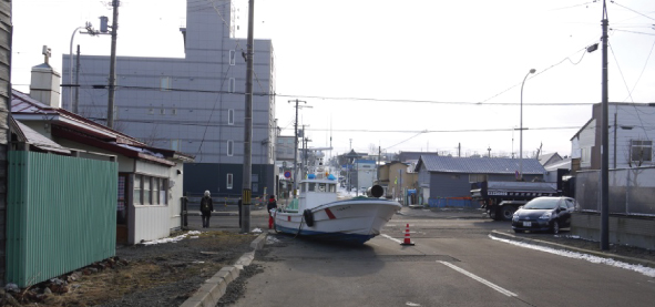 Fig. 1: Example of flood damage (grounded fishing boat in Yayoi town)
 -
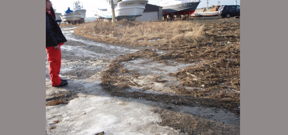 Fig. 2: Debris brought ashore (North side of Nemuro port north breakwater)
 -
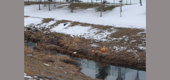 Fig. 3: Traces of high tide upstream flooding at the Hattari River
")
")
 and flood area survey results (right).")
|
Press Release |
||
|---|---|---|
| Key Points |
・Storm surge survey results by the Nemuro High Tide survey team 2014 (Associate Professor Yasunori Watanabe, Assistant Professor Ayumi Saruwatari, Assistant Professor Lima Adriano, Osamu Shinkawa, Graduate School / Faculty of Engineering, Hokkaido University, and Masaya Kato of National Institute of Technology, Kushiro College) completed . ・Investigation of the occurrence mechanism of the 2014 Nemuro storm surge ・Characteristics of the 2014 Nemuro storm surge flooding analyzed. |
|
| Overview | From Tuesday, December 16 until Thursday, December 18, Hokkaido was battered by strong winds, heavy snow, and high sea waves from a passing weather bomb. This strong winter pressure pattern grew to typhoon levels. In Nemuro city, a significant rise in sea level influenced by the high tide was observed from predawn Wednesday, December 17, exceeding quay height in port areas of Nemuro. Flooding was experienced in some areas, including Kaigan, Yayoi, Midori, Umegae, Misaki, and Nishihama towns.
This report is on the local flood survey results carried out from Friday, December 19 until Sunday, December 21, and organizes the characteristics of 2014 Nemuro Storm Surge Disaster, based on weather and oceanographic phenomena records. Wave Runup Survey Results At Nemuro port, an average 2.2m tidal prism (TP)* flood (high tide component approx. 1.8m (TP), refer to Fig. 4) approximately 15ha was observed around the pier and surrounding port-related areas, and a 1.8-2.1m (TP) flood approx. 7 ha (high tide composition approx. 1.5m (TP), refer to Fig.5) was observed in urban areas in Nemuro city (Yayoi, Midori, Umegae towns) where significant flood damage to homes occurred. As already reported by the media, inundation above floor and submersion levels, damage to fishing boats and fishing equipment (Fig.1), and sewage blockage due to deposition occurred. Flooding was also observed at the mouth and downstream areas of the Hattari River which flows through Misaki and Nishihama towns. Since the hourly rainfall during the high tide was a minimal 1-3mm, river swelling was not considered significant. Increased water level due to the high tide is assumed to have spread upstream (Fig.3) and caused the flooding, and the possibility of inland runup approximately 1km. Traces of the maximum inland runup were observed up to 3.55m (TP) on the east side of north breakwater in Nemuro port (outside the port) (Fig.2). This is considered to be caused by seawater influx due to significant wave overtopping, in addition to the rise in sea level during high tide. Note: *TP=standard mean sea level of Tokyo Bay (Tokyo Peil) Storm surge phenomenon and flood characteristics From 6-8 a.m. Wednesday morning, December 17, a central pressure approximately 948 hPa moved across the ocean north of Nemuro, with strong wind from the north recorded. An approx. 64cm rise in the tidal level due to a sea surface suction effect caused by low air pressure was observed, and the strong north wind traveling north to south caused a rising sea level drift current composition of approx. 90cm which cut off the Nemuro peninsula. In addition, a 45cm rise of the tidal level was forecasted to become a full tide. The cause of this flood was identified as the suction effect of low air pressure, resulting in a high tide, the cut off effect of the drift current, and the rise in water level due to the sea tide up to dangerous levels. These combined factors caused flood damage to lowland areas and lower river areas along the coastline on the north side of Nemuro peninsula. Recorded results showed traces 1m and more outside Nemuro port as high overtopping waves developed outside the port (a 3.55m rise in water level by high tide did not occur). In regard to areas that suffered significant flood damage, and in light of conditions where Nemuro port breakwaters (south, west, and north breakwaters), intercepted and controlled the ocean waves from the north, overtopping waves were reduced and damage was considered minimized. Conclusion Figure 6 compares the distribution of flood prediction which forecast a uniform average high tide water level rise of 2m on the topographical map (above), and actual survey results of the flooded area (below). From both sources, the flooded area and distribution are similar, so preparation of a hazard map based on flood prediction forecasted from a rise in sea level, as well as preparation of disaster prevention countermeasures for high tides, is considered to be effective. High tides commonly occur due to typhoons, but Hokkaido is not usually along the path of a typhoon. As a consequence, sufficient awareness and countermeasures for high tide disaster are lacking in Hokkaido. In addition to recent progress in tsunami countermeasures, disaster prevention and evacuation for high tides caused by a typhoon or weather bomb should be considered. |
|
| Inquiries |
Yasunori Watanabe, Associate Professor, Graduate School of Engineering, Hokkaido University TEL: +81-11-706-6185 FAX: +81-11-706-6184 E-mail: yasunori@eng.hokudai.ac.jp |
|
|
Japanese Link |
2014 根室高潮調査速報 | |